
Boundary Survey: Is Your Neighbor Over Your Property Line?
Maricopa County added 57,471 new residents in 2024 alone. That makes it one of the fastest-growing counties in the country. More growth means more fences, more additions, more driveways, and more property line disputes ending up in court. A boundary survey is the clearest, most legally reliable way to confirm where your land begins and ends. If you’ve never had one done, the information below is worth your time.
What Is a Boundary Survey?
A boundary survey is a formal measurement of your property lines. It’s carried out by a licensed land surveyor. The surveyor establishes your exact legal boundaries using public records, historical deeds, and physical fieldwork. The finished product is a certified map. Courts, lenders, and title companies all treat it as the authoritative record of your property.
The process starts at the courthouse. The surveyor pulls your deed, neighboring deeds, county plat maps, and any past filings tied to the parcel. Then they head into the field. They physically locate your property corners and mark them with iron rods or pins. The completed drawing shows exactly where your lot starts and stops. It also flags any encroachments or easements that affect your land.
In Phoenix, a standard residential boundary survey typically runs between $600 and $900 for a platted subdivision lot. Properties with unclear deed histories or irregular shapes may cost more. Most fall within that range based on 2025 project data across Maricopa County.
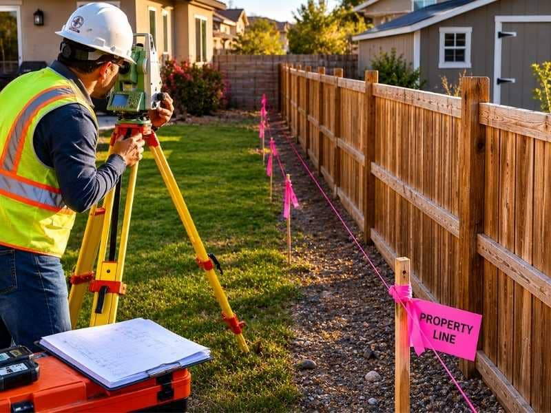
What Gets Documented in the Survey
- The exact location of all property corners, physically marked in the field
- Legal boundary lines drawn from your recorded deed
- Any encroachments from neighboring structures, fences, or driveways that cross your line
- Recorded easements that run through or border your property
- A certified survey plat showing all of the above to scale
Why Boundary Conflicts Are More Common in Phoenix Right Now
Phoenix’s metro population reached 4.887 million in 2026, up from 4.777 million just two years earlier. That kind of sustained growth puts constant pressure on established neighborhoods. Builders squeeze new homes into gaps between existing lots. Homeowners replace old fences, add pools, or expand driveways without pulling a current survey first. Most go by an old plat map. Many assume the existing fence is correct.
A lot of the time, it isn’t.
In older Phoenix neighborhoods like Laveen, Maryvale, and South Mountain, original property markers are often missing, damaged, or buried under years of landscaping. When a neighbor pours concrete or sets fence posts without checking the recorded lines, they can end up two, three, or even ten feet onto your property. They often don’t know it. By the time anyone figures it out, the structure is finished. The conversation gets a lot harder from there.
How a Boundary Survey Holds Up in a Dispute
Say your neighbor builds a shed three feet inside your property line. Without a current survey, it’s your word against theirs. With one, you have a certified legal document. It shows exactly where the boundary is and exactly how far the encroachment extends. Property dispute attorneys consistently point to the survey as the strongest piece of evidence a homeowner can bring to the table. A verbal claim or an old plat map doesn’t carry the same weight in court.
Arizona also has a legal doctrine called “boundary by acquiescence.” Under this rule, if two neighbors have both treated an informal line as the true boundary for a long period of time, a court can declare it legally binding. This can happen even if it contradicts the recorded deed. It’s a real and underappreciated risk. In neighborhoods where fences have sat in the wrong place for twenty or thirty years, the exposure is significant. A boundary survey done before any dispute arises locks in the legal line. It removes the ambiguity that acquiescence claims depend on.
When to Get a Boundary Survey
Most homeowners only think about a boundary survey after a conflict has already started. That’s the wrong time. By then, attorneys are involved and money is being spent. What could have been resolved quickly has turned into something drawn out.
The smarter approach is to get ahead of it. Here are the situations where a survey makes the most sense.
Before any construction near your lot line
Fences, pools, detached garages, backyard additions, anything built close to the edge of your lot carries risk. Going even a few inches over the line can result in a demand to tear the structure down. A survey before you break ground eliminates that risk.
When you close on a home without a current survey
Many buyers skip the survey at closing to trim costs. That leaves you without a verified record of what you actually purchased. Encroachments and easement conflicts that existed before you moved in become your problem after the fact.
When a neighbor begins construction near the shared line
Getting a survey done before a structure goes up gives you documented proof of where your line is. Trying to resolve it after the concrete is poured is far more complicated and expensive.
Before you list the property for sale
Buyers, lenders, and title companies are requesting current surveys more often. Having one ready before you list can prevent delays at closing and remove a common point of negotiation.
What Happens During the Survey
After the courthouse research is complete, the surveyor goes out to the site. They look for existing monuments: iron pipes, rebar, concrete posts, or other physical markers set during earlier surveys. Those monuments are compared against the recorded deed to verify whether the ground matches the documents.
Where markers are missing, the surveyor reconstructs the boundary from the best available evidence. That includes neighboring monuments, adjoining deeds, occupation lines, and physical site conditions. Once the analysis is complete, missing corners are set and the boundary is marked.
The final deliverable is a certified survey plat. It shows your lot boundaries to scale, the location of structures relative to those lines, any encroachments found, and any easements recorded against the property. That document is your legal record and remains useful for as long as you own the property.
The Cost Compared to the Alternative
Based on 2025 project data, homeowners paid between $244 and $919 for a residential boundary survey. Most fell in the $452 to $589 range. Complex lots, messy deed histories, and heavily built-up parcels push that number up.
Property line litigation is a different story. Legal fees alone in a boundary dispute routinely run into the thousands. Cases that go to court can cost far more. A survey ordered before a conflict develops costs a fraction of what it costs to resolve one after it starts.
Phoenix is not slowing down. New construction and infill development will keep pushing on established lot lines. Knowing where your property lines are is a practical step toward protecting what you own.